Residential Development
Residential developments are regulated by an allowed density range (minimum and maximum) measured in “housing units per acre.” Residential density is calculated by dividing the number of housings units on the site (excluding second units on single-family lots) by the net acreage of the site. Net acreage excludes land required for public and private streets, parks, and other public facilities. The diagram below shows prototypical examples of different residential densities for one-acre properties.
State planning law requires general plans to include standards for measuring population density. Population density is determined by multiplying the maximum number of units allowed within a land use designation by the average number of persons per household (as determined by US Census population data).

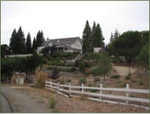 The Rural Estate Density designation generally applies to rural areas located within the eastern hills of the Hayward Planning Area. Typical building types include single-family homes, second units, and ancillary structures. Typical lot sizes are generally one acre or greater. However, Planned Developments may include the clustering of units on smaller lots to preserve common open space. Future changes to Rural Estate Density areas are expected to be limited to additional residential development on vacant lots, building and landscaping improvements, and neighborhood enhancements that create more complete, walkable, and sustainable neighborhoods.
Allowed Uses
- Detached single-family homes
Supporting Uses
- Second units
- Home occupations
- Small-scale agriculture uses, such as orchards, gardens, and raising horses, chickens, and other livestock
- Parks, recreation facilities, open space, and trails
- Community gardens
- Compatible public and quasi-public uses
- Compatible neighborhood commercial and neighborhood mixed-use
Development Standards
- Density: 0.2 to 1.0 dwelling units per net acre
- Maximum FAR: 0.4 (only applies to public and quasi-public uses, neighborhood commercial uses, and neighborhood mixed-use)
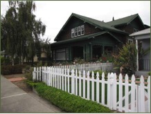
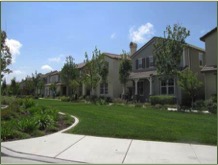
 The Suburban Density designation generally applies to rural and suburban areas located within the eastern hills of the Hayward Planning Area. Typical building types include single-family homes, second units, and ancillary structures. Typical lot sizes generally range from 10,000 square feet to one acre. However, Planned Developments may include the clustering of units on smaller lots to preserve common open space. Future changes to Suburban Density areas are expected to be limited to additional residential development, building and landscaping improvements, and neighborhood enhancements that create more complete, walkable, and sustainable neighborhoods.
Allowed Uses
- Detached single-family homes
Supporting Uses
- Second units
- Home occupations
- Small-scale agriculture uses, such as orchards, gardens, and raising horses, chickens, and other livestock
- Parks, recreation facilities, open space, and trails
- Community gardens
- Compatible public and quasi-public uses
- Compatible neighborhood commercial and neighborhood mixed-use
Development Standards
- Density: 1.0 to 4.3 dwelling unit per net acre
- Maximum FAR: 0.4 (only applies to public and quasi-public uses, neighborhood commercial uses, and neighborhood mixed-use)
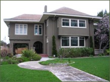
 The Low Density designation generally applies to suburban areas located throughout the Hayward Planning Area. Typical building types include single-family homes, second units, and ancillary structures. Typical lot sizes generally range from 5,000 to 10,000 square feet. However, Planned Developments may include the clustering of units on smaller lots to preserve common open space. Future changes to Low Density areas are expected to be limited to additional residential development, building and landscaping improvements, and neighborhood enhancements that create more complete, walkable, and sustainable neighborhoods.
Allowed Uses
- Detached single-family homes
Supporting Uses
- Second units
- Home occupations
- Parks, recreation facilities, open space, and trails
- Community gardens
- Compatible public and quasi-public uses
 Compatible neighborhood commercial and neighborhood mixed-use
Development Standards
- Density: 4.3 to 8.7 dwelling unit per net acre
- Maximum FAR: 0.4 (only applies to public and quasi-public uses, neighborhood commercial uses, and neighborhood mixed-use)
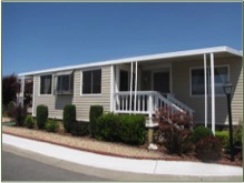 The Mobile Home Park designation applies to all established mobile home parks in the city. The typical building type is a manufactured home. Future changes to Mobile Home Parks are expected to be limited to building and landscaping improvements and various enhancements to mobile home parks that improve the quality of life of residents.
Allowed Uses
- Manufactured homes
Supporting Uses
- Community and recreational uses, such as community club houses, recreation facilities, laundry rooms, swimming pools, community gardens, playgrounds, and sports courts
Development Standards
- Density: 8.7 to 12.0 dwelling unit per net acre
- FAR: Not applicable
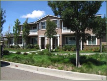
 The Limited Medium Density designation generally applies to suburban areas that contain a mix of housing types. Typical building types include single-family homes, second units, duplexes, triplexes, fourplexes, townhomes, apartment and condominium buildings, and ancillary structures. Future changes to Limited Medium Density areas are expected to be limited to additional residential development on vacant lots, building and landscaping improvements, the rehabilitation or redevelopment of older multi-family properties, and neighborhood enhancements that create more complete, walkable, and sustainable neighborhoods.
Allowed Uses
- Detached single-family homes
- Attached single-family homes
- Multi-family homes
Supporting Uses
- Second units
- Home occupations
- Parks, recreation facilities, open space, and trails
- Community gardens
- Compatible public and quasi-public uses
- Compatible neighborhood commercial and neighborhood mixed-use
Development Standards
- Density: 8.7 to 12.0 dwelling unit per net acre
- Maximum FAR: 0.5 (only applies to public and quasi-public uses, neighborhood commercial uses, and neighborhood mixed-use)
 The Medium Density designation generally applies to suburban and urban areas that contain a mix of housing types. Typical building types include single-family homes, second units, duplexes, triplexes, fourplexes, townhomes, multi-story apartment and condominium buildings, and ancillary structures. Future changes to Medium Density areas are expected to be limited to additional residential development, building and landscaping improvements, the rehabilitation or redevelopment of older multi-family properties, and neighborhood enhancements that create more complete, walkable, and sustainable neighborhoods.
Allowed Uses
- Detached single-family homes
- Attached single-family homes
- Multi-family homes
Supporting Uses
- Second units
- Home occupations
- Parks, recreation facilities, open space, and trails
- Community gardens
- Compatible public and quasi-public uses
- Compatible neighborhood commercial and neighborhood mixed-use
Development Standards
- Density: 8.7 to 17.4 dwelling unit per net acre
- Maximum FAR: 0.6 (only applies to public and quasi-public uses, neighborhood commercial uses, and neighborhood mixed-use)
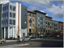 The High Density Residential designation generally applies to urban areas located near major activity centers or along arterial streets. Typical building types include townhomes, multi-story apartment and condominium buildings, and ancillary structures. Future changes to High Density areas are expected to be limited to additional residential development, building and landscaping improvements, the rehabilitation or redevelopment of older multi-family properties, and neighborhood enhancements that create more complete, walkable, and sustainable neighborhoods.
Allowed Uses
- Attached single-family homes
- Multi-family homes
Supporting Uses
- Home occupations
- Parks, recreation facilities, open space, and trails
- Community gardens
- Compatible public and quasi-public uses
- Compatible neighborhood commercial and neighborhood mixed-use
Development Standards
- Density: 17.4 to 34.8 dwelling unit per net acre
- Maximum FAR: 0.8 (only applies to public and quasi-public uses, neighborhood commercial uses, and neighborhood mixed-use)