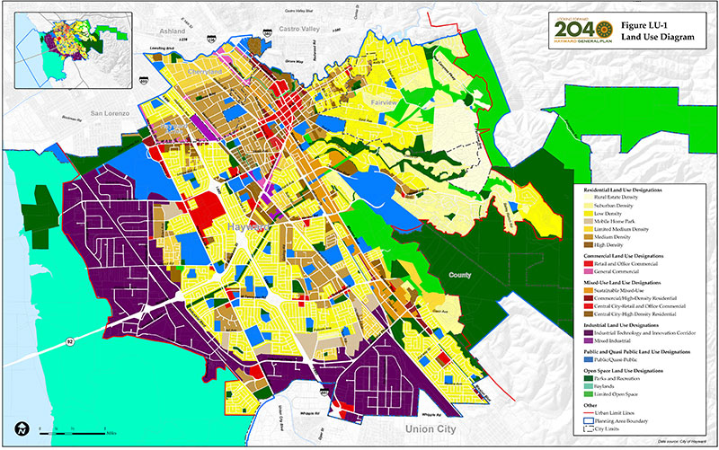
State planning law requires a general plan to describe the general distribution, location, and extent of planned land uses within the jurisdiction’s planning area. The General Plan Land Use Diagram uses color-coded land use designations to express the intended use of land across the Hayward (see Figure LU-1). For most properties, the land use designation shown on the Land Use Diagram matches the current land use of the property. This indicates that the City does not expect the use of the property to change. On other properties, the land use designation is different from the current use of the property. This indicates that the City expects the land use of the property to change as Hayward grows and develops between now and 2040.
A total of 19 land use designations are shown on the Land Use Diagram. This includes seven residential designations, two commercial designations, four mixed-use designations, two industrial designations, three open space designations, and one public and quasi-public designation. A description of each land use designation follows the Land Use Diagram. The descriptions include density and intensity standards to regulate development within each land use designation. A summary table of development standards for each land use designation is provided after the land use descriptions.
The Land Use Diagram is largely implemented through the City’s zoning regulations. Each land use designation has a corresponding set of compatible zoning districts. Many of the land use designations have more than one corresponding zoning district, which allows a more detailed interpretation of the Land Use Diagram based on existing uses and neighborhood conditions. Whereas the land use designations are intentionally broad, the zoning designations are more detailed and provide a variety of detailed development standards, including permitted and conditional uses, building heights, setbacks, lot coverage, and parking requirements. While the Land Use Diagram guides zoning, it is not the same as the City’s Map. By definition, the Land Use Diagram is intended to be more general than the Map.
Because land use designations may not reflect specific property and neighborhood conditions, they should not be interpreted to either propose or preclude land uses or developments without consideration of the guiding principles, goals, and policies of the General Plan. Site considerations related to topography, geology, or historic preservation may be more important in establishing the specific use and intensity of a particular parcel than the parcel’s specified land use designation. Similarly, the goals and policies of the General Plan may support certain types of uses that are not specifically listed within the description of the property’s land use designation. Therefore, the guiding principles, goals, and policies should always be reviewed to determine if a proposed use or development is consistent with the General Plan.
Requests to amend the Land Use Diagram are subject to a public process involving the Planning Commission and City Council. Amendments are also subject to evaluation under the California Environmental Quality Act (CEQA).